
Oregon's Highway 101: From Newport to Florence
It’s barely 50 miles from Newport to Florence along the Pacific Coast Highway, but only NASCAR aspirants would blow by the tide pools, seafood shacks, and pinch-yourself vistas in anything less than a day. Fuel up on fresh fish and chips at Newport’s Local Ocean Seafoods, and point the car south.
Just across Yaquina Bay Bridge, you’ll find the Oregon Coast Aquarium with its Passages of the Deep exhibit. Explore habitats off the Oregon coast in a journey through three acrylic tubes and get face-to-face with sharks, rockfish, and bat rays.
Eight miles beyond the bridge (and a short detour inland), you can visit a saltwater estuary and hike five miles of trails at Brian Booth State Park. Worked up an appetite? Stop by the Drift Inn in Yachats, home of the region’s best seafood chowder.
The road rears up to Cape Perpetua Scenic Area, where pullouts afford views of battered beaches and the iconic Heceta Head Lighthouse. Look below for sea lions or get a closer whiff with a 208-foot-long elevator ride down through the rock at Sea Lion Caves.
Want more? Keep driving south of Florence to visit Oregon Dunes National Recreation Area so you can see it in daylight. The dunes extend 40 miles along the seaside and have some of the planet’s tallest coastal dunes—some nearly 500 feet high.
Then return to Florence and make a reservation at the Waterfront Depot to feast on crab-encrusted halibut in a chile cream sauce. —Tim Neville
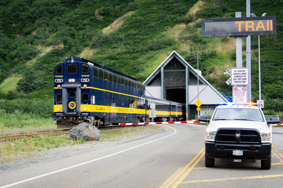
Alaska’s Highway 1: From Anchorage to Whittier
This 60-mile journey southeast from downtown Anchorage to Whittier, a port town on Prince William Sound surrounded by mountains, is known for jaw-dropping views and wildlife galore as it winds along the southern shore of Chugach State Park and follows the Turnagain Arm of the Gulf of Alaska beneath dramatic views of the Chugach Mountains.
Multiple trailheads along the route let you stretch your legs on the low-elevation, 9.5-mile Turnagain Arm Trail that runs parallel to the road. Watch for moose and bears, especially in spring, as you walk. For more wildlife viewing, stop at Beluga Point Lookout, where you might see majestic beluga whales feeding in summer, and Windy Corner, known for sightings of Dall sheep with curled horns. The last 11 miles to Whittier on Portage Glacier Road pass through the Moose Flats Day Use Area, an ideal spot for waterfowl watching.
Stop in Girdwood for seafood or find an outfitter to take you on a paddling excursion, then travel through the 2.5-mile, one-lane, train-and-car Anton Anderson Memorial Tunnel, an architectural marvel cut through the base of a mountain. (Direction of travel changes every half hour, check the schedule, plan ahead for the toll, and note that oversize vehicles including RVs are only allowed during certain times of the day.) In Whittier, explore the high density of brilliant blue-white glaciers of Prince William Sound on a day cruise or take the ferry to Valdez. —Jennifer Burns Bright
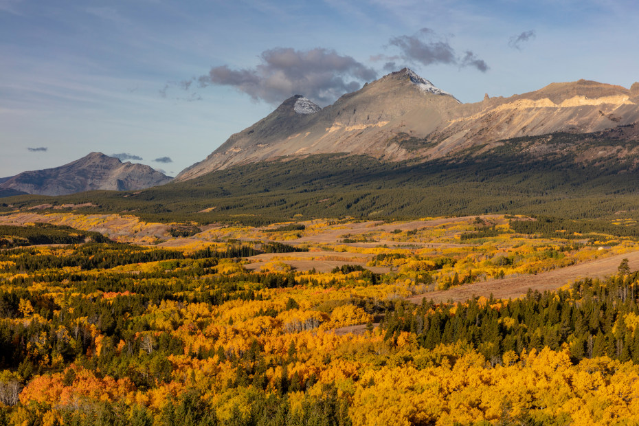
Montana’s Highway 2: From Kalispell to East Glacier Park
Open year-round in all but the harshest winter weather, this 88-mile excursion from Kalispell, a charming historic town in Western Montana’s Glacier Country, takes you along the southern border of Glacier National Park to the community of East Glacier Park. The road skirts the rushing waters of the Middle Fork of the Flathead River.
After spending the night in Kalispell, head out to West Glacier at the entrance of the park. Here you’ll find gateway communities that offer guided fishing or snowmobiling excursions and exhilarating hikes. Stop at the Huckleberry Patch in Hungry Horse for treats made with Montana’s favorite berry. At West Glacier, make a quick detour to Lake McDonald for a photo opp, then enjoy a hearty lunch in Essex. Don’t miss the pull-off for Silver Staircase Falls, a lovely tiered cascade, at Mile 188.
You’ll pass through the Continental Divide at Marias Pass, then head north to East Glacier Park for comfortable lodging. From there, you can either head north to St. Marys to make a loop back through the park on the seasonal Going-to-the-Sun Road (where vehicle reservations may be necessary) or head out into the Blackfeet Nation to the Museum of the Plains Indian in Browning. —Jennifer Burns Bright
The Point Arena Lighthouse is a beacon for sailors off the California coast.
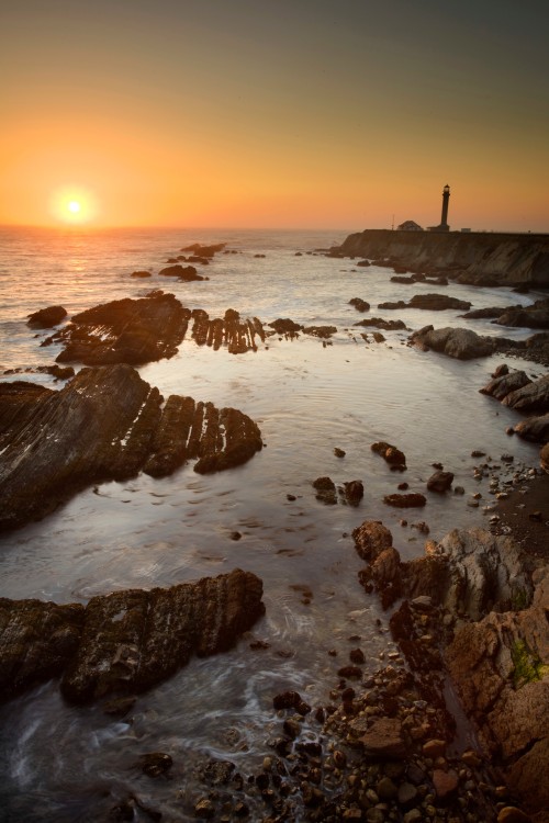
California's Highway 1: From Gualala to Fort Bragg
Brilliant sunsets, weathered barns, hillside pastures, lively arts, and redwood-fringed ocean views: This 60-mile stretch of rural Highway 1 tracing the jigsaw curves of California’s coastal bluffs stirs reflection and romance.
At the Gualala Arts Center, a popular venue, you can pick up a list of its gallery exhibits, live music shows, and theater performances by artists from Mendocino’s creative coast and beyond. The Shoreline Highway’s curves are best savored with frequent infusions of good coffee. Fill up your travel mug at Trinks Cafe and grab a turkey sandwich with house-made cranberry sauce for the road. Thirty minutes up the coast, the 145 steps at the 1908 Point Arena Lighthouse provide a workout as stimulating as the views. In winter and late spring, watch for spouting gray whales on their regular commutes.
Farther on, wind and churning waves relentlessly nibble at the shoreline cliffs and towering sandstone sea stacks at Greenwood State Beach in Elk. Don’t miss the park’s visitor center with its dizzying mural of the rickety 19th-century trestle that once carried railcars transporting redwood timber to tall ships. Perched on coastal bluffs, the well-preserved clapboard village of Mendocino deserves extended exploration. Even if you’re short on time, be sure to pause at the wild and lovely Mendocino Headlands State Park to marvel at the roiling surf powering through rock tunnels and spray-spewing blowholes.
Dreamy coastal stretches finally give way to the outskirts of Fort Bragg. At the 47-acre Mendocino Coast Botanical Gardens, heathers, heritage roses, and pink- and fuchsia-colored rhododendrons reign in early spring through early summer.
Buy a snack pack of smoked cheddar and some German sausage for the return drive at Roundman’s Smokehouse in Fort Bragg. Or, for a savory souvenir, take home a party-size fillet of alder- and apple-smoked salmon or smoked albacore. —Deborah Franklin
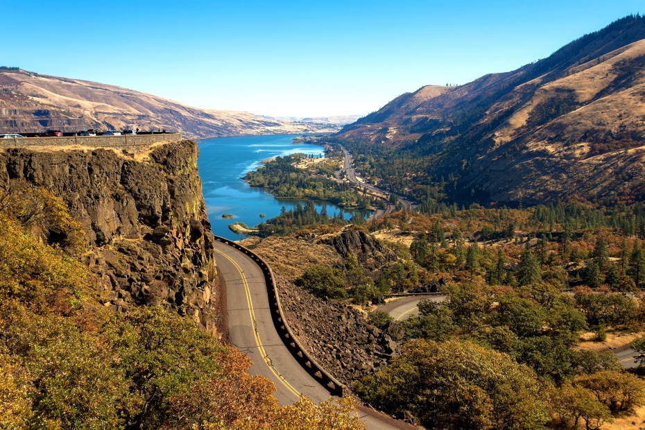
Historic Columbia River Highway winds its way up to the top of Rowena Crest in the Columbia River Gorge.
Oregon's Historic Columbia River Highway: From Troutdale to Hood River
Waterfalls plunging down sheer cliffs, and sunlight breaking through maples and firs—the Columbia River Highway packs plenty into 77 miles. Summer attracts crowds seeking shade and cool mists; other seasons allow more solitude. Whenever you visit, start by climbing the highway from Troutdale to the domed Vista House, famous for 360-degree views of the Columbia River Gorge. Next, wend your way downhill on a serpentine road.
The route flattens out at the bottom, aka waterfall central. Latourell Falls looks inviting from the car, but you’ll want to walk closer. The honeycombed basalt at its base is as picturesque as the water. Drive on and the waterfalls keep gushing: Wahkeena, Horsetail, and, of course, 620-foot Multnomah. Other falls—including Punch Bowl, Ponytail, and tall but delicate Elowah—lie just a short hike from the road.
The highway merges with I-84, which heads past the Bonneville Dam to the town of Cascade Locks, where you can picnic next to the river or catch a cruise on the Columbia Gorge riverboat. Beyond that, you can explore Hood River, known for wineries, pears, and windsurfers, and The Dalles, where the lush gorge finally gives way to the dry expanse of northeastern Oregon. —Chris Woolston
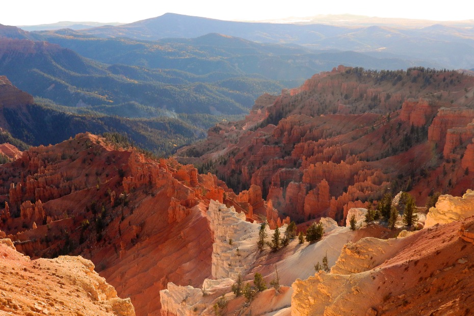
From Point Supreme, Utah's breathtaking Cedar Breaks National Monument shows its stripes.
Utah's Scenic Byway 143: From Parowan to Panguitch
Southwest Utah—home to Bryce Canyon and Zion national parks—delivers big-time scenery. That’s what you get on the 55-mile stretch between Parowan and Panguitch, known as the Patchwork Parkway: a lot of wow per mile. From Parowan, the road leaves the desert and climbs up the forested slopes of the Markagunt Plateau, a geologic layering of sandstone, limestone, and lava flows. Eight miles in, you can take an easy hike to Hidden Haven, where a 20-foot waterfall plunges over a red rock cliff.
A series of switchbacks takes you upward to Brian Head Resort at 9,600 feet. Against expectations, the road keeps climbing as you approach the turnoff for Cedar Breaks National Monument, a stunning three-mile-across amphitheater of red-and-orange limestone cliffs and spirelike hoodoos.
Finally, it’s time to start heading downhill. The eastern side of the plateau features large meadows blending with stands of spruce and aspen. Trees thin out as you approach the notoriously fishy Panguitch Lake. Then it’s on to Panguitch itself, another small town on the edge of the desert. —Chris Woolston
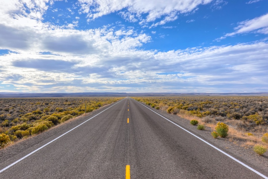
Nevada's Highway 50 offers big vistas and a seemingly endless road.
Nevada's Highway 50: From Baker to Ely
Fuel up for this trip with a plate of pancakes at Kerouac's Cafe in tiny Baker. You’re about to drive 63 miles from here to Ely—a short leg of “America’s Loneliest Road.”
You start across a flat expanse of sage and rabbitbrush just northeast of Great Basin National Park and the rugged Snake Range. Then the highway climbs along the Sacramento Pass, where old logging roads lure hikers and mountain bikers.
The drive descends into Spring Valley, home to 66 whirring, 400-foot-tall wind turbines. After taking a hard westerly turn toward the Schell Creek Range, you’ll have a good photo op of a long, straight stretch of deserted asphalt. Pass—or stop at—the antler-festooned Major’s Station Bar and RV Park before climbing Connors Pass.
From here the highway drops into the Steptoe Valley, where elk gather in the fall and spring. The final haul to Ely is so quiet that the westbound lane is occasionally used for fun runs, which mostly turn into walks. That’s the Loneliest Road: no traffic and no reason to hurry. —Chris Woolston
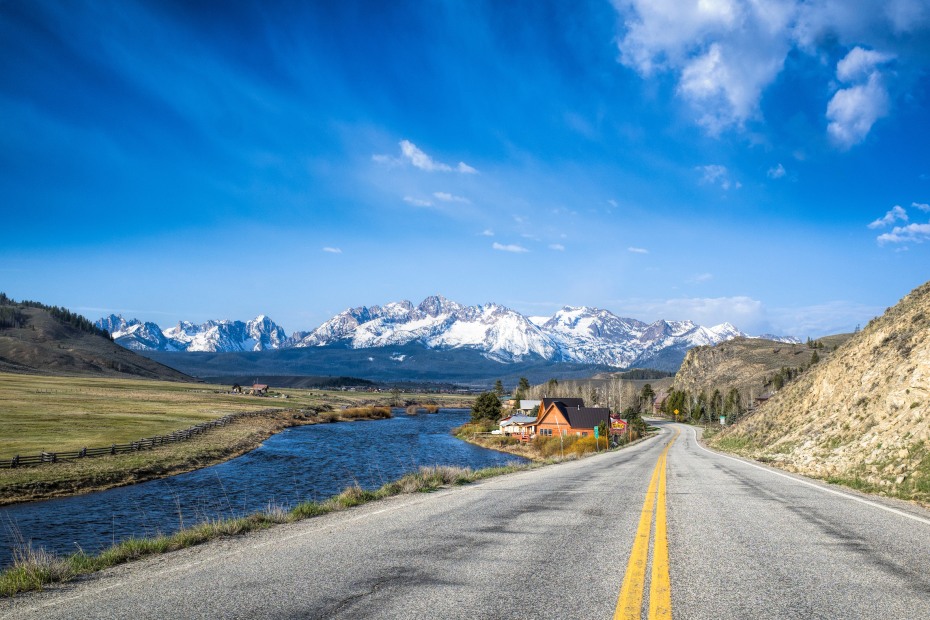
The Salmon River carves out the Stanley Basin along Idaho's Highway 75.
Idaho's Highway 75: From Hailey to Stanley
The 73-mile trip starts near chic Sun Valley at Hailey, known for its people-watching and intimate restaurants. The highway continues toward the trails, mountainscapes, and wildlife of the Sawtooth National Recreation Area. At Billy’s Bridge, watch for mountain goats on the slopes. Consider soaking in the Easley Hot Springs pool, and afterward pull in at Galena Lodge for a Grown-up Grilled Cheese.
As you wind over the 8,701-foot Galena Summit, the Stanley Basin unfolds before you, cradling the Salmon River against a backdrop of the jagged Sawtooth Range. From here, you can hit the trails at Alturas or Pettit alpine lakes and enjoy a huckleberry shake at Smiley Creek Lodge. At Redfish Lake, a blue gem surrounded by pines and peaks, visitors can rent kayaks and paddleboats or relax on a cruise.
The town of Stanley marks the end of the drive. Still feeling adventurous? Why not raft the Salmon—a wet finish to a wild trip. —Gayle Keck
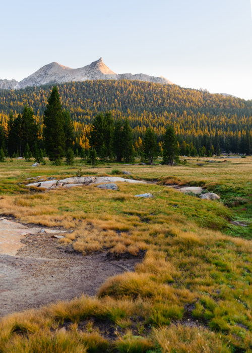
California's Highway 120 passes by Tuolumne Meadows in Yosemite.
California's Highway 120: From Groveland to Mono Lake
To relish Yosemite’s granite grandeur without the constant crowds, consider taking the 98-mile drive that climbs 9,950 feet from rolling foothills on the west to the crest of the Sierra, then descends to otherworldly Mono Lake.
Groveland has been provisioning miners and adventurers since 1848. These days, you can find flaky pastries and strong coffee at Mountain Sage Cafe.
As you head east up the Sierra, the hillside oaks give way to fragrant pines near the south fork of the Tuolumne River. At Rainbow Pools, a noisy 15-foot waterfall splashes bathers in a natural swimming hole. At Crane Flat, you can take a 2.5-mile round-trip walk to a group of old-growth giants in Tuolumne Grove.
From the Crane Flat turnoff, head east on Tioga Road for 30 miles, where you can view Yosemite’s granite grandpappy, Half Dome, and the less famous Clouds Rest, from the panoramic view at Olmsted Point, 8,420 feet above sea level.
A few minutes up the road, pull over at Tenaya Lake, a great spot for picnics. A paved walkway on the north side provides access to wheelchairs. At 8,600 feet, Tuolumne Meadows offers fields of wildflowers, scattered lakes, and the gentle, meandering Tuolumne River.
Thirteen miles downhill from the summit, high desert awaits. Craggy mineral formations called tufa towers rise like icebergs from 760,000-year-old Mono Lake, a meeting spot for gangs of migrating birds. Human travelers are welcome too.
If you’re hungry after crossing the Sierra, head next to the tiny town of Lee Vining and its small but well-stocked Mono Market, where you’ll find burritos, apple strudel, guacamole, and organic produce. Take your picnic to Mono Lake County Park to eat beneath the willow trees and trek along the short boardwalk for close views of Virginia rails, American avocets, phalaropes, and other migratory birds. —Deborah Franklin
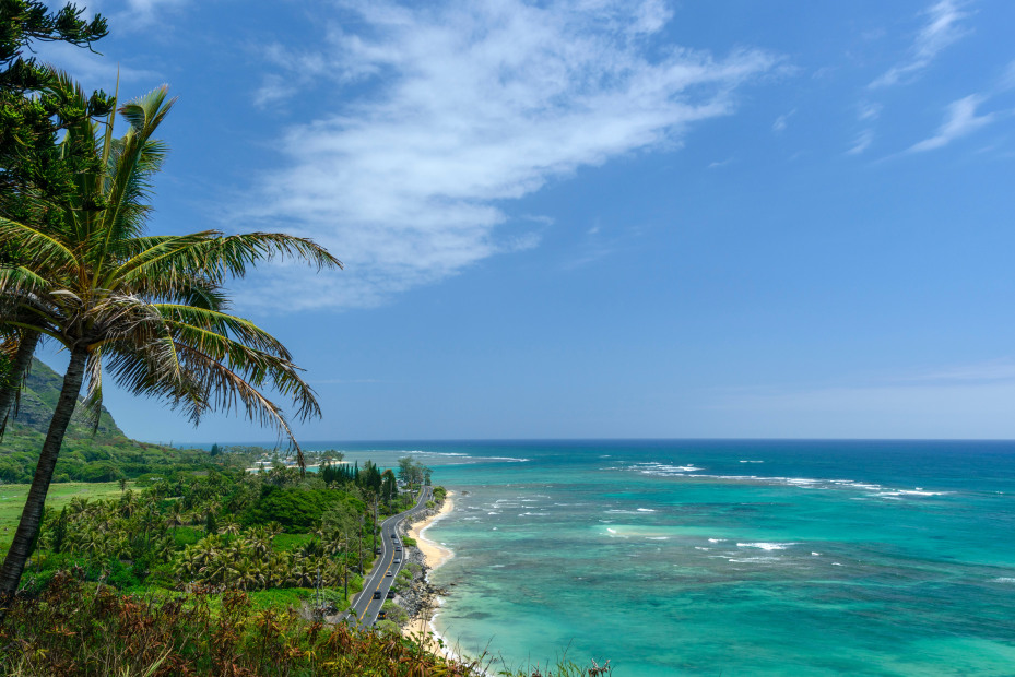
Hawaii’s Highway 83 from Kaneohe to Haleiwa
From spotting migrating whales in winter to enjoying the surf and summer breezes, this 40-mile stretch of the Kamehameha Highway, named after the unifier of the Hawaiian Islands who established the Hawaiian Kingdom, takes visitors along the North Shore of Oahu.
Start your journey with a horseback riding tour to learn about the ecology and history of the 4,000-acre Kualoa Ranch Private Nature Reserve on the eastern edge of the island. As you head out, take in the verdant cliffs of the Kānehoalani Mountains and dramatic surf breaks.
Embrace a slower pace and pull off at any of the beaches that line the road to dig your toes into the sand and cool off. If you’re visiting in October through February, you can get off the beaten path with a birdwatching tour at the James Campbell National Wildlife Refuge. Held just once a week on Saturday mornings during the winter, the small tour invites you into the typically closed refuge to carefully learn about Hawai‘i’s endangered waterbirds and migratory shorebirds and waterfowl in their habitat.
Just outside the refuge in the historic sugar plantation town of Kahuku, refuel with delectable shrimp served over rice at Fumi’s Kahuku Shrimp food stand. Then head south to Haleiwa, a charming historic town with a downtown great for browsing. Pick up some gear at Surf N Sea, browse art galleries, or cool down with shave ice. Beginning surfers can take lessons or rent a board at Pua’ena Beach park where swells are typically gentle enough for first-timers in the summer months. —Jennifer Burns Bright