
Zooming down the interstate, fixed on your destination, it’s easy to forget that rich history lies just beyond the billboards. In centuries past, countless explorers, pioneers, and American Indians traversed the West on horseback, by wagon, or on foot. And thanks to the National Trails System, it’s possible to follow in their steps.
Of the 19 Historic Trails, many pass through the forests, mountains, and deserts of the West, tracing the wanderings of early travelers. These trails aren’t intended as through routes for hiking or driving. Instead they suggest wonderful short detours from the fast lane, mixing history and fun. So if you find yourself nearby, add a time-traveling road trip to your itinerary.
1. Oregon National Historic Trail
Road trip: Montpelier, Idaho, to Baker City, Oregon.; US-30, I-15, I-86, I-84; 446 miles
The Oregon National Historic Trail follows the routes of determined westward-bound emigrants from Missouri through seven states. From about 1812 to 1866, an estimated half million people traveled the 2,000-mile trail, with some splitting off to California or Utah before reaching western Oregon. Depending on weather, accidents, disease, and other factors, an average wagon trip could take five months. Despite the hardships they endured, approximately 90 percent of the travelers made it to their goal.
National Oregon / California Trail Center: At this interactive center in Montpelier, Idaho, actors in period costume lead hour-long treks (May–October) that include a computer-simulated ride in a covered wagon.
Soda Springs: The hot, mineralized water of these natural pools was used to wash clothes and bake bread that one pioneer journal described as “light as any prepared with yeast.” A soak in the outdoor geothermal pools at Lava Hot Springs, Idaho, 22 miles farther down the highway, makes a fine road break.
Shoshone Falls: As you skirt Twin Falls, Idaho, make the same detour that many pioneers did to see Shoshone Falls. Late summer water levels are often low, but at a towering 212 feet high, the falls’ wide, horseshoe-shaped cliff is still plenty impressive.
Three Island Crossing State Park: At this riverside park, exhibits and guided walks explain the potentially deadly choice faced by travelers here: Cross the broad Snake River using a trio of islands as stepping-stones, or take the punishing, arid land route to Fort Boise, Idaho.
National Historic Oregon Trail Interpretive Center: On the scrubby high desert outside Baker City, Oregon, miles of wagon ruts can still be seen on the easy 180-foot Ruts Access Trail or the 1.5-mile round-trip Panorama Point Trail. “For many visitors, the sight of the ruts is deeply moving,” says lead park ranger Kelly Burns. “They’re our most powerful reminder of the emigrant experience.”
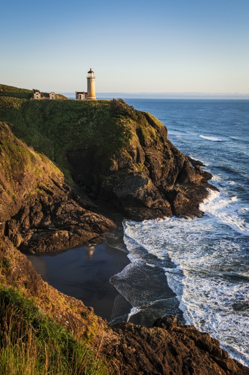
Cap off your journey with a sunset at Cape Disappointment State Park.
2. Lewis and Clark National Historic Trail
Road trip: Lewiston, Idaho, to Astoria, Oregon; US-12, WA-124, US-395, I-82, I-84, I-5, I-30; 432 miles
Led by Meriwether Lewis and William Clark, the Corps of Discovery charted the western reaches of a United States still in its infancy. The 3,700-mile Lewis and Clark National Historic Trail follows their 1804–1806 journey from the Midwest to the Pacific Ocean and back, a trip marked by scientific discoveries, encounters with indigenous cultures, and perilous river navigation.
Hells Gate State Park: On the Snake River in Lewiston, Idaho, drop by the Lewis and Clark Discovery Center for a short film about the expedition’s journey through the state. From Lewiston, you can also take a jet boat up the Snake to Hells Canyon.
Lewis and Clark Trail State Park: Wander 37 acres of old-growth forest in eastern Washington where the group camped on their way home. Then enjoy a modern amenity: warm blackberry cobbler from the Weinhard Café in Dayton.
Sacajawea Historical State Park: This park in Pasco, Washington, and the Corps of Discovery room in its interpretive center (open April 1 to October 31) overlook the confluence of the Snake and Columbia Rivers.
Columbia Gorge Discovery Center and Museum: How did the crew haul its 30 tons of supplies and equipment? You’ll find the answer at this site in The Dalles, Oregon (AAA members get $1 off admission.) As you head toward Portland, look for the Columbia River Gorge’s famous waterfalls.
Fort Clatsop: History comes to life near Astoria, Oregon, at a replica of the Corps’ log encampment. Across the Columbia in Cape Disappointment State Park, Washington, make a short climb to McKenzie Head. The ocean view remains as stirring as it was when William Clark stood on that very spot.
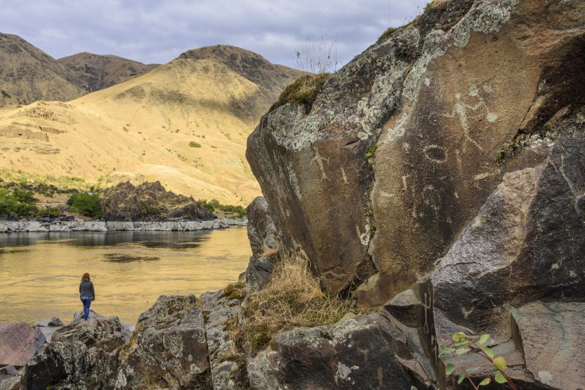
Buffalo Eddy is covered with 4,500-year-old Nez Perce petroglyphs.
3. Nez Perce National Historic Trail
Road trip: Wallowa Lake, Oregon, to Lolo, Montana; OR-351, OR-82, OR-3, WA-129, US-12; 309 miles
“This trail commemorates a very sorrowful chapter in American history,” says Vivian Wilson, a Nez Perce tribe member and a ranger with the multisite Nez Perce National Historical Park. Winding for 1,170 miles through four states, the trail follows the route taken by 750 Native men, women, and children who, for three months in 1877, fled from and skirmished with the U.S. Army before finally giving up just 40 miles south of a would-be refuge in Canada.
Wallowa Lake: Overlooking Wallowa Lake near Joseph, Oregon, is the grave site of Old Chief Joseph, the mid-19th century leader of the Wallowa band of Nez Perce who refused to sign a treaty relinquishing their ancestral homelands. His son, Chief Joseph, was among those fleeing the army.
Nez Perce National Historical Park Visitor Center: On the way to Lapwai, Idaho, detour to Buffalo Eddy to view 4,500-year-old Nez Perce petroglyphs, then continue to this visitor center that maintains a small collection of other artifacts, including beaded clothing and a 29-foot dugout canoe. At nearby Fort Lapwai—where the Nez Perce met with the army in a last effort to remain on their land—the old officers’ quarters still stand.
Heart of the Monster: Exhibits at this 53-acre site near Kamiah, Idaho, retell the Nez Perce creation story involving the slaying of a giant creature. A short trail takes you to a rock formation said to represent the monster’s heart.
Looking Glass Village: The site of Chief Looking Glass’s Idaho camp, which the army attacked even though the chief’s band had remained neutral, is now occupied by the Kooskia National Fish Hatchery. Park there to access two easy walks: one around a mill-pond, the other a quarter-mile trail with panels telling the story of the attack.
Lolo Pass Visitor Center: Displays at this modern log building with picnic facilities cover the Nez Perce journey over the Lolo Pass and into Montana’s Bitterroot Valley. Their flight would continue two months more until a weary Chief Joseph, seeing the suffering of his people, declared: “From where the sun now stands, I will fight no more, forever.”
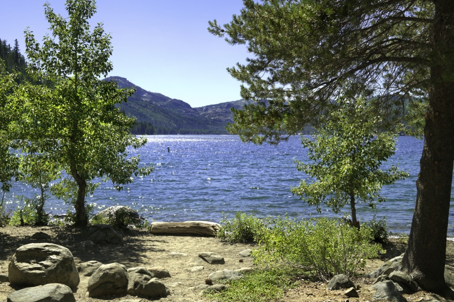
The lake at Donner Memorial State Park dazzles in summer.
4. California National Historic Trail
Road trip: Elko, Nev., to Sacramento, California; I-80; 410 miles
When James Marshall discovered gold in 1848 in the Sierra Nevada foothills, he accelerated a dream already in the making—the California Dream—that would seize the nation. Between 1841 and 1869, some 250,000 emigrants, fueled by visions of quick fortune or simply a better life, headed west to California on a trail that started in Missouri, splintered over mountains, and ended 2,000 miles later at points around the Golden State.
The California Trail Interpretive Center: Exhibits at this site near Elko, Nevada, give an overview of the trail. During Trail Days, hosted annually in May, the center comes alive with the rumble of covered wagons and the smell of campfire stews as costumed reenactors demonstrate the skills needed to survive the trek.
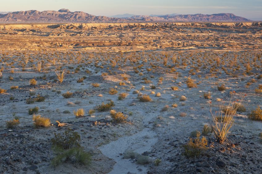
Forty Mile Desert: Beyond Lovelock, Nevada, I-80 continues through an eerie alkali wasteland where an 1850 survey counted nearly 10,000 dead mules, horses, and cattle, as well as 953 graves. Among the most dreaded sections of the trail, crossed by night when possible, Forty Mile Desert still appears forbidding.
Truckee: After passing through Reno—in an area pioneers called Truckee Meadows, where they rested before crossing the Sierra Nevada—you’ll come to Truckee, California. The former stage stop boomed with the arrival of the railroad in 1868, and today its historic downtown houses a lively restaurant scene that includes Pianeta Ristorante, serving house-made ricotta ravioli.
Donner Memorial State Park: Stop by the visitor center outside Truckee to learn about the ill-fated 1846 Donner Party, which was forced to overwinter in the high mountains. Stretch your legs on the Summit Lake Trail, an easy 4.7-mile loop, or sign up for one of the historic interpretive walks offered in the area during the annual Donner Party Hike.
Marshall Gold Discovery State Historic Park: As you descend the Sierra Nevada foothills, detour along State Route 49 to see the place that changed California history. The park features a museum, original and reconstructed buildings (including a replica of Sutter’s Mill, where the first gold was found), docents in period attire, and do-it-yourself gold panning. Unlike the forty-niners, you’re almost sure to take home a few flakes of the real deal.
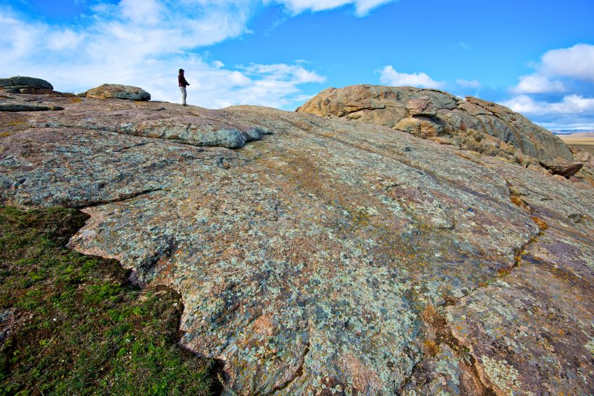
Independence Rock still bears thousands of names and dates engraved or painted there by pioneers.
5. Mormon Pioneer National Historic Trail
Road trip: Casper, Wyoming, to Salt Lake City, Utah; WY-220, US-287, WY-28, US-191, I-80; 415 miles
In 1846, after enduring years of persecution in Nauvoo, Illinois, the Mormon community made the decision to pull up stakes and trek westward to a new Zion. Over the next 23 years, nearly 70,000 church members traveled along this trail—and trial—of faith, traversing five states on a 1,300-mile route that largely overlapped the Oregon Trail and terminated in the Salt Lake Valley. With the 1869 completion of the transcontinental railroad, which passed through Utah, the trail was no longer used.
Casper: Fort Caspar, a reconstructed 1865 military outpost with log buildings and a stockade, is located in Wyoming near a major emigrant crossing of the North Platte River. At the National Historic Trails Interpretive Center four miles north, visitors can see how wagons were packed and experience a simulated river crossing.
Independence Rock: The namesake granite dome at Independence Rock State Historic Site, Wyoming, still bears thousands of names and dates engraved or painted there by pioneers. Devil’s Gate, another major landmark, is six miles farther west. For the best view of this 370-foot-high cleft carved by the Sweetwater River, stop at the turnout on the north side of Highway 220.
Mormon Handcart Historic Site: The visitor center here focuses on travelers who pulled their belongings in carts without horses or oxen. You can walk all or part of a five-mile round-trip trail with a replica handcart loaned by the center.
South Pass: At the South Pass rest area on Highway 28, take in the wide plateau of sagebrush and grass that was a pivotal point on the westward trails. “South Pass was where emigrants crossed the Continental Divide,” says Todd Guenther, a historian at Central Wyoming College. “It was a major symbolic moment.”
This Is The Place Heritage Park: Check out the 1850s boot shop, tiny 1868 log cabin, and dozens of other historic buildings at this Salt Lake City attraction to get a sense of what life was like for those who completed the trek. Afterward, over curry at Himalayan Kitchen, ponder what the pioneers would make of the vibrant, cosmopolitan city their settlement has become.
Eclectic decor covers the walls inside the bar at the International Hotel along Highway 50 in Austin, Nevada.
6. Pony Express National Historic Trail
Road trip: Ely to Carson City, Nevda; US-50; 320 miles
From April 1860 to October 1861—when it shut down following the completion of the transcontinental telegraph—the Pony Express used horse-and-rider relay teams to deliver mail across the 1,966 miles between Sacramento, California, and St. Joseph, Missouri, in as few as 10 days—half the time of stagecoach mail. Nevada was among the toughest portions of the route. “Apart from the harsh climate and terrain, there were far fewer settlements,” says Cindy Daffron, the executive director of the Pony Express National Museum in St. Joseph. “And the threat of Indian attack was constant.”
Eureka: Settled in 1864, this old mining town boasts a cache of gorgeously restored 19th-century buildings including an opera house. The town sits on “the loneliest road in America,” a stretch of Highway 50 passing through craggy mountains and across scrubby desert flats similar to that crossed by the Pony Express riders, who were typically 16–17 years old (with some as young as 11) and weighed just 100 to 125 pounds, to keep the horses’ loads as light as possible.
Cold Springs Pony Express Station: About 50 miles west of Austin, Nevada, and 1.5 miles west of the Cold Springs Station Resort, pull into trailhead parking for an easy, three-mile-roundtrip hike to the ruins of the Cold Springs Pony Express station. The rudimentary stone walls, backed by mountains and topped by an endless desert sky, are haunting reminders of the isolation endured by both riders and station masters.
Sand Mountain Recreation Area: At the entrance to the recreation area, you’ll find the stone ruins of another Pony Express station, Sand Springs, which had been buried under dunes for countless years and was excavated in 1976 by an archaeological team from the University of Nevada, Reno.
Fort Churchill State Historic Park: After passing through Fallon and coming to Silver Springs, detour for nine miles south on Highway 95 Alternate to Fort Churchill State Historic Park. Now an impressive, preserved adobe ruin with a visitor center, the fort was established in 1860 in response to ongoing Indian raids, and it, too, was used as a Pony Express stop.
Virginia City: Take a roughly eight-mile detour into rollicking, historic Virginia City, which was already booming during the Pony Express years thanks to the gold and silver mined from the nearby Comstock Lode. These days, you can still wet your whistle with a sarsaparilla (or something stronger) at the Bucket of Blood Saloon, one of the town’s period saloons. And as you do, raise your glass high to the scrappy lads of the Pony Express.
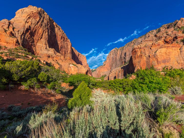
Explore the spectacular five-mile scenic drive through Zion National Park’s Kolob Canyons.
7. Old Spanish National Historic Trail
Road trip: Green River, Utah, to Las Vegas, Nevada; I-70, US-89, UT-20, and I-15; 418 miles
Among the trade routes that have crisscrossed the West since time immemorial, none is more legendary than the Old Spanish Trail. Pack mule trains traversed its 2,700 miles between Mexican settlements at Santa Fe and Los Angeles starting in 1829, when 25-year-old merchant-explorer Antonio Armijo traveled west with New Mexico woolen goods to exchange for California mules and horses. The mule trains must have presented quite a sight: One contemporary observer noted “the line of march of this strange cavalcade occupied an extent of more than a mile.” The trail declined after 1848 with Mexico’s loss of its northern territories to the United States.
Green River: Crossed by 19th-century traders, the town’s namesake river now draws white-water thrill-seekers and picnicking families alike. At the John Wesley Powell River History Museum, which showcases the historical and cultural significance of the Green and Colorado Rivers, outdoor panels provide information about the Old Spanish Trail and local geology.
San Rafael Swell: Leaving Green River, you’ll pass through some of the desert Southwest’s most arresting scenery, including this massive, fortresslike sandstone ridge that forced mule trains to veer to the north. Pull into the Black Dragon Canyon View Point, about 20 miles west of town, to get a jaw-dropping view.
Fremont Indian State Park and Museum: Check out ancient Fremont pottery, baskets, and arrowheads unearthed during interstate construction. The easy, 1.2-mile roundtrip Cave of 100 Hands Trail leads to an unforgettable sight: images of human hands rendered in prehistoric times on rock surfaces in red, orange, and mustard pigment.
Cedar City: The home of the Utah Shakespeare Festival is flush with food options such as the beautifully blistered, thin-crust pies from Centro Woodfired Pizzeria. About 22 miles beyond town, the spectacular five-mile scenic drive through Zion National Park’s Kolob Canyons leads through magnificent chasms of crimson rock.
Old Las Vegas Mormon Fort: Check out the adobe remnants of the first permanent non-native settlement in the Las Vegas Valley, established in 1855 near the spring-fed meadows (vegas in Spanish) for which Antonio Armijo named the area. Armijo may have been the first guy with something to sell who passed through Vegas, but he certainly wouldn’t be the last.
The Juan Bautista de Anza National Historic Trail commemorates the journey of Spanish friars, soldiers, and colonists who trekked from southern Arizona into California.
8. Juan Bautista de Anza National Historic Trail
Road trip: Nogales to Yuma, Arizona; I-19, I-10, and I-8; 300 miles
Running from Nogales, Arizona, to San Francisco, this 1,200-mile trail commemorates the remarkable 1775–76 journey of 240-plus Spanish friars, soldiers, and colonists who, under the command of veteran explorer Juan Bautista de Anza, trekked from southern Arizona and into California to establish the first non-native settlement on San Francisco Bay. “Many parts of the trail let you experience things that have not changed since the expedition,” says Greg Smestad, a descendant of de Anza party members and the author of an online guide to the trail. “You can see literally the same trees my ancestors did, smell the same kinds of flowers, and hear the same species of birds or sometimes the same sacred music being performed in a mission.”
Tumacácori National Historical Park: About 20 miles north of Nogales, Arizona, this park holds a poignant colonial-era church, kept in a state of arrested ruin, made of limestone hauled from the Santa Rita Mountains visible in the distance. Stretch your legs on the flat, mostly shaded path along the Santa Cruz River that follows the de Anza party’s actual route.
Tubac Presidio State Historic Park: The preserved ruins of the presidio where de Anza served as commander stand alongside a small museum housing American Indian, mission-era, and 19th-century Arizona territory artifacts. On select days from January through March, you can park at Tumacácori, take a shuttle to Tubac, and join a ranger-led, four-mile interpretive walk back.
Mission San Xavier del Bac: This whitewashed church is a gem of Spanish Colonial architecture and a still-vibrant house of worship, its cool, dark interior filled with original 18th-century murals and statues. Continue on through Tucson, or detour through Saguaro National Park for pristine desert views like those the expedition would have seen.
Casa Grande Ruins National Monument: Another optional detour leads off I-10 to this one-square-mile park established in 1892 to preserve the remnants of an ancient Sonoran Desert people’s farming community. The formidable ruins of a four-story house that was seen by de Anza, who noted it in an expedition journal, can be visited on guided or self-guided tours.
Yuma: This is where the de Anza party crossed the Colorado River with help from the Yuma (Quechan) tribe. On the edge of the city’s lively downtown, stroll the riverside trail linking restored wetlands that will seem, just as they did for the de Anza party, a true oasis after all the desert travel.