
In the summer of 1916, excited motorists jumped into their Model T's to observe the official opening of Oregon's brand-new Columbia River Highway, a feat of engineering that finally connected drivers to the waterfalls and other wonders of the Columbia River Gorge. "Before the road, if you wanted to see the waterfalls, you had to flag down a train or a steamboat," says local historian Len Otto.
Those first wide-eyed visitors, zooming along at speeds sometimes over 35 mph, drove through freshly blasted tunnels and gawked at panoramas from overlooks far above the grand river. The 70-mile drive marked a major shift in the way people thought about travel. Although the highway was built for commerce and to get people from point A to point B, it was also designed to maximize the scenery along the way. (In 1986, President Ronald Reagan designated the entire gorge a National Scenic Area, the country's second.)
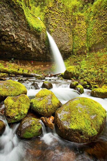
Waterfalls on the Columbia Gorge
These days, two sections of the Historic Columbia River Highway remain, connected by a short stretch of Interstate 84. Together, they offer the best—though not the fastest—way to see the area. The route adds up to about 70 miles of attractions and distractions that can easily fill a day.
The first section of the old two-lane highway, carefully and thoroughly restored over the years, starts 17 miles east of Portland in Troutdale, a small town that embraces the road the way other towns honor local celebrities. This burb of nearly 16,500 is home to the King of Roads-Byway of the People show at the Troutdale Historical Society's Barn Exhibit Hall, a combination of photos and memorabilia documenting the highway's history. Knowing the story adds even more appeal to the drive. Visionaries Sam Hill and Samuel Lancaster had studied highways along the Rhine River in Europe, then brought the same style and techniques—stone arch guardrails, elegant bridges, and wide, sweeping turns to tame steep climbs—to the road along the gorge. "It's hard to imagine a road being built with such artistry today," historian Otto says.
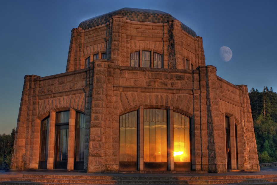
Vista House perches 733 feet above the river.
From Troutdale, the road climbs to the gorge's rim and one of the loftiest views of the water. Just past the tiny town of Corbett is the Portland Women's Forum State Scenic Viewpoint, where the full grandeur of the panorama spreads before you. The domed Vista House, sitting on a nearby promontory, makes for an impressive (and often snapped) photo.
Almost every traveler pulls over at Vista House, an elegant rest stop with marble floors and opalescent glass windows that look out over miles of sky, water, and rock. From here, you can contemplate the natural forces that created the scene: Between 12,000 and 15,000 years ago, an ice dam holding back Glacial Lake Missoula collapsed, unleashing a cataclysmic flood that blasted through the Columbia River valley. The wall of water shaved off the sides of the valley, turning gentle slopes into sheer cliffs and small creeks into plunging waterfalls.
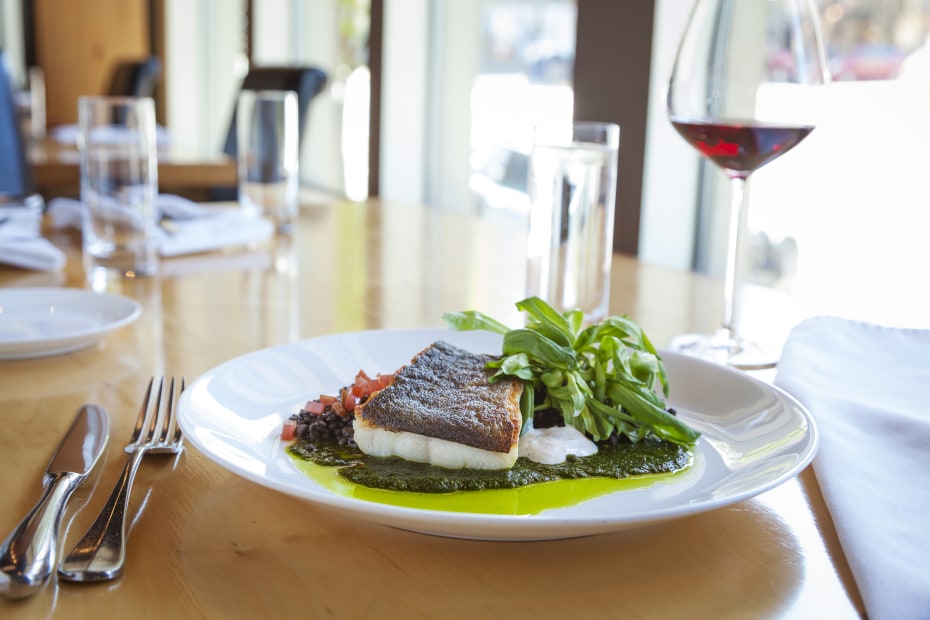
At Celilo, black cod sits on a bed of green herb and pepper sauce.
Winding downhill through a thick forest of ferns, maples, and Douglas firs, you arrive at Latourell Falls, one of nearly 80 cascades that grace the gorge. While many of those falls can only be reached by a strenuous hike, some of the most dramatic specimens—such as Latourell—happen to be near the road.
For the next 11 miles, the challenge is simply deciding which of the drive-up waterfalls are worth getting out of the car for a closer peek. Spoiler alert: They all are. Multnomah Falls—a two-tier drop that adds up to a spectacular 620 feet of white water against gleaming basalt cliffs—is the most popular waterfall, but locals have other favorites, too. Troutdale resident Nell Simien prefers less heralded 176-foot Horsetail Falls, about 2.5 miles farther along the road. A short, easy walk upstream leads to 88-foot Ponytail Falls, where a path cuts behind the water, providing a backside view of the spray and a cool spot to linger on a summer day.
Columbia Gorge Pleasures
The historic highway merges with the interstate at the little community of Dodson, and it's another 35 miles before drivers can get back to the old road. Although the interstate may lack retro charm, this portion of the drive contains lively highlights. At Cascade Locks, visitors take rides on the Columbia Gorge stern-wheeler. You can see Herman the Sturgeon, a celebrity fish who swims with rainbow trout at the Bonneville Fish Hatchery. Hikers head out from the Eagle Creek trailhead to the much photographed Punch Bowl Falls, and all sorts of people take the off-ramps to Hood River, the epicenter of gorge life.
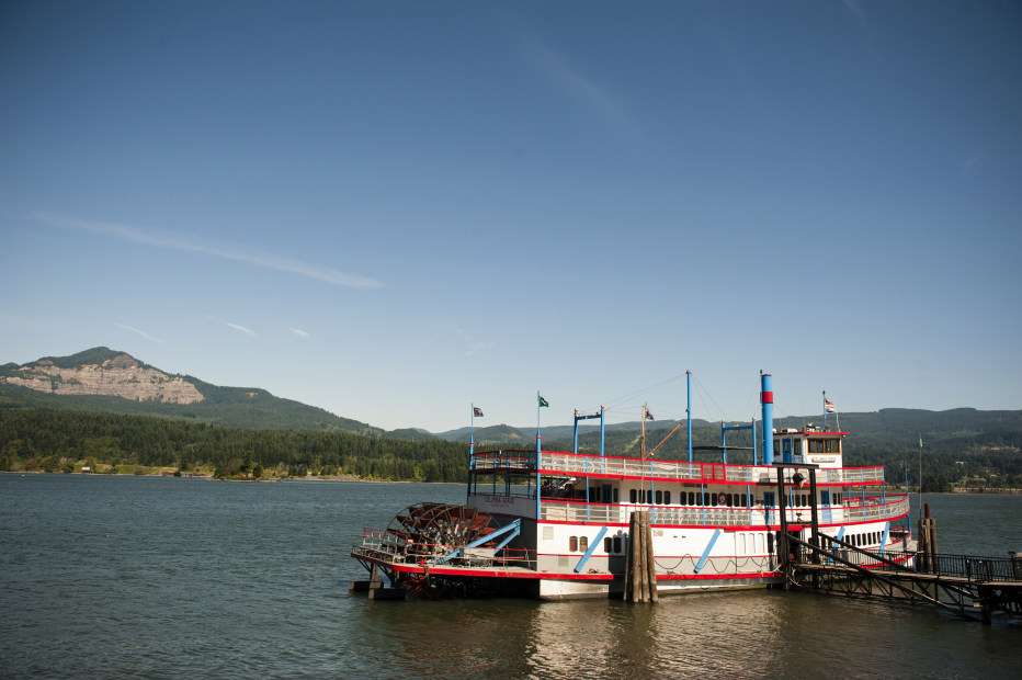
The triple-decker Columbia Gorge stern-wheeler offers 360 degrees of stellar views.
With about 7,500 residents, Hood River is a small city with a big reputation as a travel getaway. Outdoor adventurers know it as an excellent spot to windsurf across Columbia whitecaps or bomb down a mountain bike trail. Shoppers discover that the walkable downtown is a fun place to pick up outdoor gear at Doug's Hood River or maybe a garnet pendant at Hood River Jewelers. Food and wine lovers find it ideal for relaxing and enjoying epicurean pleasures.
Mild weather and fertile volcanic soil in the Hood River Valley have certainly created a bounty: Wineries pour pinot noir, chardonnay, syrah, and an array of diverse wines from nearby vineyards; taprooms sell hard cider from apples grown in the area's vast orchards. Dinner at Celilo Restaurant becomes a leisurely tour of regional flavors. Chef Ben Stenn, who trained at the l'École de Cuisine La Varenne in Burgundy before working as a chef in New York City, now takes a thoroughly Oregonian approach to the kitchen. He buys morel mushrooms, figs, pork, and other staples from his neighbors and lends his expert touch to every dish—such as a salmon fillet served with potatoes confit, roasted baby carrots, and fennel with chioggia beet sauce and olive oil. "I want to keep the ingredients simple," he says. "But I want to show off a bit."
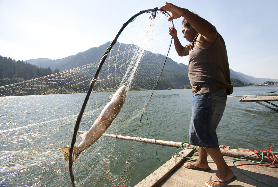
Yakama angler Joe Sutterlickt uses a hoop net to catch salmon.
Hood River is also the gateway to a 4.5-mile portion of the historic highway that is closed to motorized traffic, giving cyclists, joggers, and walkers a chance to experience views of the Columbia at their own pace. The car-free stretch starts at the west Mark O. Hatfield trailhead just outside town and runs to the community of Mosier. Three miles in, you arrive at the Twin Tunnels, two passageways that bore through solid basalt—about 80 feet for the west tunnel and 290 feet for the east tunnel—in a testament to the power of well-placed dynamite.
Sunbaked Beauty from Hood River to the Dalles
East of Hood River, the ferny, drippy green of waterfall country changes to a drier, more rugged landscape that impresses with its immense scale. Leaving the interstate at the Mosier exit, you can catch the final drivable expanse of the historic highway, a quiet 16-mile section that winds past outcroppings of black rocks and stands of oak trees on the approach to The Dalles.
The road passes a large colonial-style house and cherry orchard on the Mayerdale estate before reaching Rowena Crest, an open plateau above the Columbia. The waterway appears wide and mighty from up here, but the most remarkable sight might be the horseshoe loop of the highway below. It's like a car commercial in real life, with nonprofessional drivers on a very open course.
The highway eases down from the plateau to The Dalles, a sunbaked town surrounded by high desert. Here you can take weekend tours of The Dalles Dam, watch salmon power up fish ladders, and enjoy unobstructed views of Mount Hood. The town is also home to the Columbia Gorge Discovery Center and Museum, an eye-catching building whose exhibits include the type of cargo Lewis and Clark's expedition hauled through the gorge en route to and from the Pacific, as well as mammoth molars and other remnants of the Ice Age. A continuously running 1916 movie clip shows tourists motoring past waterfalls on the brand-new Columbia River Highway.
Machinery has changed in 100 years, but the nation's first highway built to celebrate the scenery still lives up to its original promise: to deliver people to a place that deserves to be seen, now and for many anniversaries to come.
Before You Go
A timed-use permit is required to access the Waterfall Corridor on the Columbia River Gorge Highway from between May 24 to Sept. 5, 2022. Multnomah Falls also requires timed-use permits during this time. Permits are required in both areas between 9 a.m. and 6 p.m. each day during this period. Permits must be purchased online in advance.